Mardi 27 juillet 2021. Tarva-Storfosna.
Mardi 27 juillet 2021. Tarva-Storfosna.
Toujours beau et chaud mais avec un fort vent du sud-est. Nous sortons les
vélos et allons faire toutes les routes de Tarva. C’est une ile verdoyante,
cultivée mais plus au nord qui a encore de nombreuses traces de la guerre. Nous
roulons sur des routes faites par les Allemands, voyons de nombreux blockhaus
et même un port utilisé pour décharger des canons. Nous allons aussi voir
« Mammuten » (le mammouth) sans savoir ce que c’est. Mais une notice
explique que c’était un gigantesque radar. Le nord de l’ile est toujours
utilisé pour des exercices militaires par l’armée norvégienne. Nous roulons
vers le sud-ouest et passons la digue qui relie Tarva à une autre ile, Karlsøy.
Nous montons sur une tour d’observation et avons une belle vue sur 360˚. Tarva est
une ile agréable, bien entretenue et de place en place des petites notices
renseignent les touristes sur l’histoire et la nature de l’ile. Retour à Maja
après 18 km, lunch puis nous partons vers 15 h en direction de Storfosna, une
ile plus au sud. Traversée sans histoire et nous ancrons à 18 h dans une
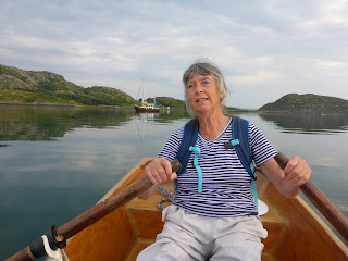
grande baie bien protégée. Petite promenade à terre, Jens rame en allant et moi
en revenant, diner et évènement rarissime, nous lisons et buvons notre thé
dehors à 22 h, sans kjeledress !
Distance
Tarva-Storfosna : 13 mn (23 km)
Florvåg-Storfosna: 1 541
+ 13 = 1 554 mn (2 797 km)
Tuesday July 27, 2021. Tarva-Storfosna
Still beautiful and warm but with a strong
south-easterly wind. We take out the bikes and ride all the roads in Tarva. It
is a green island, cultivated but further north that still has many traces of
the war. We drive on roads made by the Germans, see many bunkers and even a
port used to unload cannons. We go also to see "Mammuten" (the mammoth)
without knowing what it is. But a notice explains that it was a gigantic radar.
The north of the island is still used for military exercises by the Norwegian
military. We drive southwest and pass the dike that connects Tarva to another
island, Karlsøy. We climb onto an observation tower and have a beautiful 360˚
view. Tarva is a very pleasant island and from place to place, small notices
give information about the history and nature of the island. Return to Maja
after 18 km, lunch then we leave around 3 pm in the direction of Storfosna, an
island further south. Crossing without history and we anchor at 6 pm in a large
bay well protected. Short walk ashore, Jens is rowing on the way to land and I
on the way back, dinner and extremely rare event, we read and drink our tea
outside at 10 p.m., without kjeledress!
Distance
Tarva-Storfosna: 13 nm (23 km)
Florvåg-Storfosna:
1,541 + 13 = 1,554 nm (2,797 km)


No comments:
Post a Comment